Ground Truths - Importance of Location Accuracy for Geotechnical Testing
Introduction
Global Navigation Satellite Systems (GNSS) with Real-Time Kinematic (RTK) positioning have become essential tools for accurately locating geotechnical test sites. Whether drilling boreholes, digging test pits, or conducting in-situ soil testing, precise horizontal and vertical coordinates mean that site data can be reliably mapped and located. Modern GNSS receivers using RTK corrections can now deliver centimeter-level accuracy, a significant improvement over standard GPS. This accuracy is no longer reserved for specialists – recent advances have made high-precision RTK GNSS surprisingly affordable and accessible. As a result, industry guidelines and regulations are increasingly emphasizing the use of RTK GNSS for recording test locations.
Too often, we have encountered geotechnical reports including statements like the following (or worse - with no descriptions):
"Locations of borings shown in our figures were estimated based on site plans provided to us."
"Ground surface elevations shown in our boring logs were estimated by interpolating between contour lines from available USGS topographic maps for the site."
"Horizontal locations and ground surface elevations of borings were measured in the field using cellphone-grade GPS, with horizontal accuracy of +/- 30 ft, and should be considered approximate."
On a site with any topographic relief, inaccuracy in horizontal locations of tests translates into significant inaccuracy in vertical locations when interpolating from site plans or topographic maps. At InnovoGeo, we believe in the value gained through utilization of high-quality insitu testing, which often results in vertical resolutions of a few inches. Would you want your high-quality subsurface data to be inaccurate horizontally and vertically orders of magnitude greater than its resolution? We certainly don't - and believe there is a better way, and that your projects deserve more accurate subsurface data.
InnovoGeo’s Commitment to Precision with the Emlid Reach RX
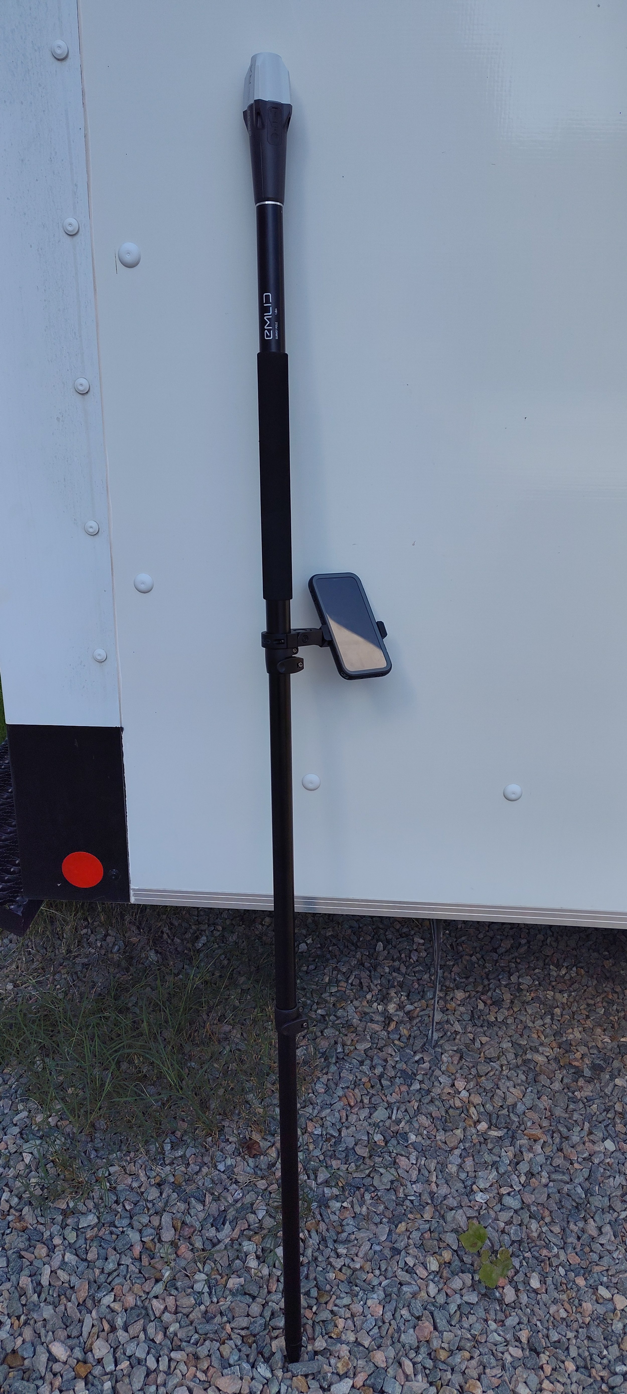
At InnovoGeo, we recognized early on that investing in RTK GNSS capability would provide greater value with our geotechnical services. That’s why since our inception, we have equipped our field team with the Emlid Reach RX – an easily-transportable, multi-constellation RTK rover that delivers centimeter-accurate positions in real time. This device connects to local reference networks (NTRIP) to obtain differential corrections, allowing us to get a fixed RTK solution usually within seconds.


Did this investment come with upfront and ongoing costs? Absolutely.
Our early adoption of high-precision GNSS was driven by our focus on quality and client service. By logging each test location’s coordinates and elevation with survey-grade accuracy, we ensure that our borehole logs, test pit records, and monitoring points can be reliably used in design and permitting. For example, if a project requires integrating our soil data into a BIM model or aligning it with a site CAD plan, our accurate coordinates make the process seamless. We’ve found that this level of precision often exceeds what is minimally required by current guidelines – a fact that provides extra assurance to our clients and reviewers. (Indeed, in light of the recent USACE and DOT guidance, our approach of using RTK from the start now appears prescient, effectively “future-proofing” our data against rising standards.)
Another benefit of using the Reach RX is efficiency. Traditional surveying to mark test locations can be costly and time-consuming, but with a mobile RTK rover we can obtain ground coordinates on the fly and at much lower cost. The rover’s compactness and simple operation means even a single technician can capture points without a dedicated survey crew. We also configure our data collection to output coordinates in whatever datum the project needs – whether it’s WGS84 latitude/longitude as recommended for USACE mapping, or a local State Plane or UTM grid for engineering plans. Having precise geolocation for every test point not only improves our deliverables, it also cultivates trust.
In support of our RTK GNSS workflow, InnovoGeo maintains a monthly subscription with RTKdata.com, giving us access to a reliable NTRIP correction network across Central Virginia and our wider service area. This subscription ensures that our Emlid Reach RX rovers can obtain rapid, high-quality RTK fixes without the need to set up a base station on every project. By leveraging this correction service, we minimize setup time, maintain consistent accuracy across jobsites, and provide geotechnical test locations that meet the centimeter-level standards expected by agencies and clients alike.

Why Accurate Coordinates Matter in Geotechnical Testing
In geotechnical engineering, accurate location data underpins the quality of any site investigation. Small errors in position or elevation can lead to big misunderstandings about subsurface conditions, and lead to major cost and schedule implications during construction. Key reasons precise GNSS coordinates are important include:
Data Integration: Geotechnical data (soil profiles, groundwater levels, etc.) needs to be correlated with site plans, GIS maps, and design models. High-accuracy coordinates (in a consistent datum) allow test results to be overlaid on project drawings or digital terrain models without misalignment. This is crucial for larger projects where dozens of boreholes and test points must be mapped relative to each other and to planned infrastructure.
Horizontal Precision: Knowing the exact horizontal position (latitude/longitude or grid coordinates) of a test location ensures you’re characterizing the correct spot on site. For example, two borings just a few meters apart might encounter very different soil conditions; RTK GNSS helps document exactly where each was drilled. Standard single-frequency GPS might have ±3–5 m error, which could be the difference between being inside or outside a proposed building footprint. RTK GNSS, by contrast, can tighten horizontal uncertainty to a few centimeters, reducing ambiguity in test locations.
Vertical Precision: Elevation is equally critical. Many geotechnical analyses (slope stability, groundwater flow, settlement) depend on accurate elevation of strata and water tables. By capturing test elevations relative to a standard datum (e.g. NAVD88), engineers can compare soil layer depths and water levels across a site with confidence. Precise vertical data also means that when you log a “ground surface elevation” for a borehole, it truly reflects reality – not an estimate off a topo map.
Evolving Standards and Guidelines for GNSS in Site Investigations
Recognizing these benefits, various agencies have begun to set standards and guidelines for geolocation accuracy in environmental and geotechnical data collection. A recent example comes from the U.S. Army Corps of Engineers (USACE), which in July 2025 released guidance on using high-accuracy GNSS for mapping aquatic resource boundaries. The USACE document recommends collecting RTK GNSS data with roughly 3 cm horizontal and 5 cm vertical precision whenever feasible, and at least under 50 cm error as a permissible maximum. The guidance emphasizes that RTK-capable GNSS units – once cost-prohibitive – are now available for only a few hundred dollars and can achieve <2 cm accuracy with RTK differential corrections. In other words, today there is little excuse for using imprecise GPS when affordable tools can deliver survey-grade results. Consistent use of such tools, according to USACE, will enhance the accuracy and replicability of mapping and delineation work across projects. Recent USACE solicitations for geotechnical investigations have also required boring locations to be determined using RTK GPS units with an accuracy within 0.2 feet.
Standards specific to geotechnical engineering are also emerging. For example, the Virginia DOT's Manual of Instructions states "longitude and latitude information shall be provided with six digits past the decimal point (decimal-degree units) and a negative value for longitude. Ground surface elevation (NAVD88) is required for all boring locations accurate to 0.1 feet."
A difference of six decimal places in latitude or longitude (0.000001 degrees) corresponds to approximately 11.1 cm of distance at the equator. This distance is consistent for latitude, as one degree of latitude remains fairly constant from the equator to the poles.
However, for longitude, the distance represented by a degree decreases as one moves away from the equator towards the poles due to the convergence of meridians. At the equator, a 0.000001 degree difference in longitude is also about 11.1 cm, but this distance shrinks significantly at higher latitudes. For example, at 45 degrees latitude, the same 0.000001 degree difference in longitude represents only about 7.8 cm.
North Carolina DOT's Geotechnical Investigation and Recommendations Manual requires that "all distances and boring locations shall be measured and reported to the nearest 1 foot horizontally. All elevations and depths shall be measured and reported within 0.1 feet accuracy vertically."
California DOT (Caltrans) updated its geotechnical manual in 2023 to require precise coordinates for all subsurface exploration points. Caltrans explicitly warns against using low-accuracy devices: “Use tools that can achieve accuracy that meet the reporting requirements. Do not use mobile phone or consumer-grade GPS devices to determine the borehole location.” This is a clear directive that professional-grade GNSS (or traditional surveying) must be employed so that reported borehole locations and elevations meet engineering accuracy standards (typically reported to the nearest 0.1 ft, or ~3 cm, according to Caltrans).
These forward-looking requirements underscore a broader trend: geotechnical data is increasingly managed in geographic information systems, and consistent, high-quality coordinate data is needed to make that possible. Some project specifications now require digital submission of borehole locations, pushing firms to adopt precise GNSS or survey methods instead of hand-taping distances from nearby features. In the past, a geotechnical engineer might locate test points by measuring off a site plan or using a handheld GPS with several meters of error; today, best practice is to use RTK GNSS or total stations to get it right the first time. Standards for environmental studies, construction surveys, and infrastructure projects around the world are converging on the idea that sub-meter (and preferably centimeter) accuracy is the new normal for recording field data.
Conclusion
RTK GNSS technology has become indispensable for geotechnical test location accuracy. High-precision positioning is no longer a luxury reserved for surveyors; it’s a practical necessity for anyone collecting field data that will inform design or regulatory decisions. The ability to pinpoint test locations to within a few centimeters horizontally and vertically greatly enhances the value of geotechnical data. Recognizing this, agencies in the U.S. (and abroad) are updating guidelines to encourage or require the use of accurate GNSS methods over coarse handheld GPS or interpolation. Recent USACE guidance and state DOT standards reflect a growing consensus that reliable spatial data is critical for environmental and engineering projects. InnovoGeo’s investment in the Emlid Reach RX from day one was rooted in this understanding of ground-truth accuracy. By leveraging RTK GNSS for projects, we gain confidence that our test locations are truly ground truths – precise, consistent, and ready to support the successful development of our clients’ projects.
References
U.S. Army Corps of Engineers – Recording Aquatic Resource Delineations Using GNSS (Guidance Document, July 2025) swf.usace.army.mil
Virginia DOT - Manual of Instructions (MOI), Chapter III - Geotechnical Engineering (11/1/2024) www.vdot.virginia.gov
North Carolina DOT - Geotechnical Investigation and Recommendations Manual (Updated 9/9/2021) connect.ncdot.gov
Caltrans Geotechnical Manual – Borehole Location (Revision Apr 2023) dot.ca.govdot.ca.gov