Ground Truths - Vegetation Clearing and Private Utility Locating
The safest geotechnical investigation begins long before the drill rig arrives.
When most people think about a geotechnical investigation, they picture a drilling rig collecting soil samples or a cone penetration test (CPT) rig advancing into the ground. It's easy to assume that's where the investigation begins. In reality, one of the most important phases of any successful geotechnical investigation occurs before a single piece of equipment ever arrives on site.
Proper vegetation clearing and private utility locating are two of the most overlooked, but most valuable, steps in reducing project risk. While these activities may seem like minor site preparation tasks that add unnecessary costs, they play a critical role in protecting workers, property, project schedules, and budgets. They also improve the quality and efficiency of the investigation itself.
Like many aspects of engineering, the best-managed risk is the one that never materializes.
Of course, every project is different, and every project has a budget. The level of site preparation appropriate for a geotechnical investigation should be based on a thoughtful assessment of project-specific risks rather than a one-size-fits-all approach. For example, on a remote, undeveloped tract with little existing infrastructure, the risk reduction provided by comprehensive private utility locating may be significantly lower than on an urban infill site or an active commercial or industrial facility where numerous private utilities may be present. Likewise, some sites offer excellent access via existing gravel roads, paved surfaces, or maintained lawns that require little or no vegetation clearing. However, access across landscaped or manicured areas may warrant the use of ground protection mats or other protective measures to minimize rutting, track marks, and restoration costs, which should also be considered during project planning.
The need for vegetation clearing can also vary considerably depending on site conditions and the time of year. During the winter months, dormant vegetation often provides improved visibility and easier access, while actively maintained sites or agricultural fields with low-growing crops may require little preparation. In the Mid-Atlantic region, however, undeveloped properties and neglected portions of otherwise maintained sites can quickly become overgrown with dense brush, vines, thorny vegetation, and poisonous plants within a single growing season. What may appear to be a simple walk to a proposed boring location from aerial imagery can become a slow, hazardous, and inefficient task once crews arrive in the field. The preferred sequence for private utility locating and vegetation clearing depends on site conditions and the anticipated utility network - but often starting with vegetation clearing is preferred.
The objective is not to maximize site preparation on every project - it is to make informed decisions that reduce risk where it matters most.
Looking Below the Surface Starts with Seeing Above It
Geotechnical engineering is built around reducing uncertainty beneath the ground surface through subsurface investigation. Ironically, many of the greatest hazards encountered during a subsurface investigation exist above ground or just below the surface before drilling even begins.
Dense vegetation, fallen trees, overgrown brush, hidden drainage structures, steep slopes, abandoned foundations, fences, and miscellaneous debris can all create unnecessary hazards for field crews and equipment. These obstacles often conceal conditions that cannot be identified during a desktop review or from aerial imagery alone. Even something as simple as waist-high vegetation can hide holes, exposed utilities, concrete remnants, or unstable ground conditions. Removing these avoidable hazards allows the investigation to focus on what it was intended to evaluate: the subsurface.
Vegetation Clearing Is About Much More Than Access
Clients sometimes view vegetation clearing primarily as a way to create access for drilling equipment. While access is certainly important, the benefits extend much further. Proper clearing improves visibility around exploration locations, allowing crews to identify potential hazards before equipment is mobilized or placed at proposed test locations. It reduces slips, trips, falls, contact with ticks, other insects and wildlife, and other common field injuries by exposing uneven terrain, hidden obstacles, and drainage features.
Forestry mulching performed with a skid steer is often one of the most effective methods for preparing sites for geotechnical investigations. Unlike conventional land clearing, forestry mulching typically requires minimal ground disturbance because vegetation is shredded in place rather than uprooted, helping preserve existing grades, reduce erosion potential, and minimize impacts to surrounding soils. The operator can also selectively remove only vegetation below a specified diameter, such as brush, saplings, and small trees, while leaving larger, mature trees undisturbed whenever practical. This approach is both environmentally responsible and highly efficient, allowing 8- to 10-foot-wide access corridors to be established quickly for drilling rigs, support vehicles, and utility locating personnel without the need for extensive grading or debris removal. For many undeveloped sites, forestry mulching provides an ideal balance between improving site accessibility and minimizing disturbance prior to construction.
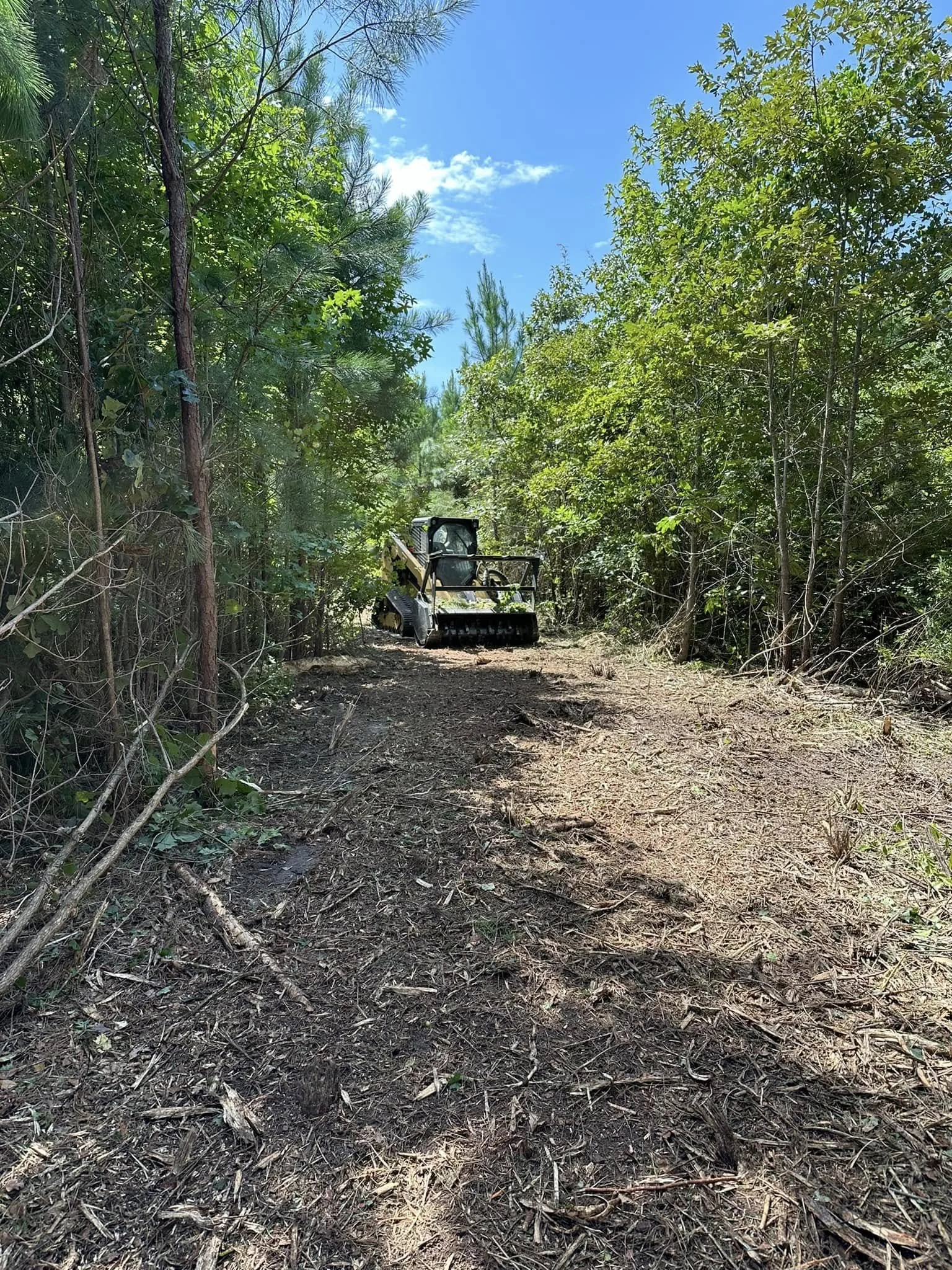
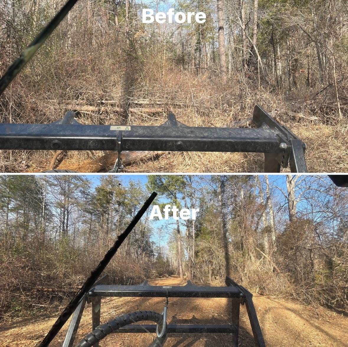
Forestry Mulching Photos Courtesy of Ironwood Land Management LLC
Adequate clearing also helps protect specialized geotechnical testing equipment. Hydraulic hoses, fuel and water lines, electronic sensors and wires, and tracked undercarriages are all susceptible to damage from stumps, rocks, hidden debris, and dense woody vegetation. Hydraulic fluid or fuel leaks and spills can result in environmental contamination and costly and lengthy delays to completion of scopes - leading to unhappy clients and property owners. Even for low grass and crops, vegetation clearing has benefits.
From a technical perspective, clearing also improves investigation quality. Survey crews can establish exploration locations more accurately, satellite-based equipment often performs better with reduced overhead canopy, photographs become more useful for documentation, and field personnel can position equipment more precisely where intended.
Perhaps most importantly, well-prepared sites allow field crews to focus on collecting high-quality engineering data and less time manually clearing brush or relocating exploration points in the field. The result is a safer, more efficient investigation that often reduces overall project costs.
One Call Does Not Locate Every Utility
Most owners are familiar with calling 811 before excavation. This is an essential and legally-required first step for any underground excavation, but it is important to understand what 811 does, and what it does not do. Public utility locating services are generally intended to identify publicly owned underground infrastructure. Many privately owned utilities fall outside the scope of those services.
Examples of private underground utilities commonly encountered on commercial and industrial properties include:
Electrical services beyond the utility meter
Private water distribution lines
Sewer laterals
Irrigation systems
Fire protection piping
Site lighting circuits
Parking lot electrical systems
Fiber optic and communication lines
Security and access control wiring
Industrial process piping
Abandoned utility infrastructure with unknown locations
Propane and natural gas lines
Drain tile systems
These utilities often cross exactly where geotechnical exploration locations are planned. Unless a qualified private utility locator is engaged, these utilities may remain completely unknown until they are struck.
Private utility locating is typically performed using a combination of specialized technologies, with the appropriate method depending on the type of utility and site conditions. The most common tools include electromagnetic (EM) utility locators, which detect conductive metallic utilities or tracer wires; ground penetrating radar (GPR), which uses high-frequency radio waves to identify both metallic and many non-metallic underground features; and transmitter/receiver systems, where a signal is induced directly onto a known utility to trace its alignment. More advanced investigations may also incorporate acoustic methods, CCTV inspection of utility pipes, or vacuum excavation (potholing) to expose and verify the precise location of critical utilities. Because each technology has inherent limitations, experienced utility locating firms often employ multiple methods to improve confidence and reduce the likelihood of missed or inaccurately marked utilities.
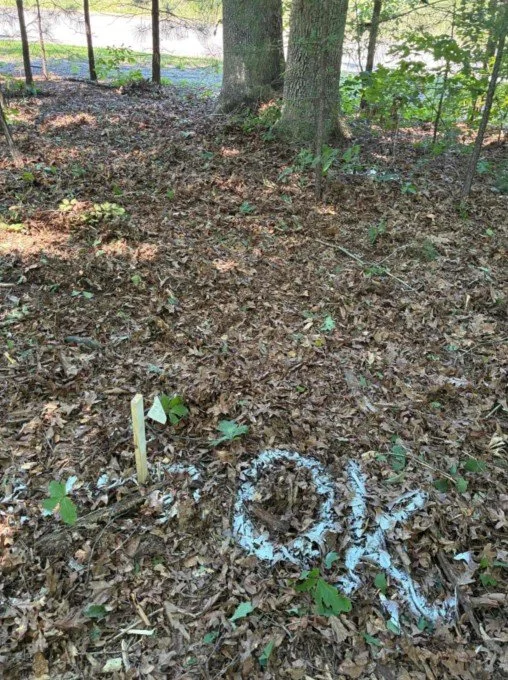
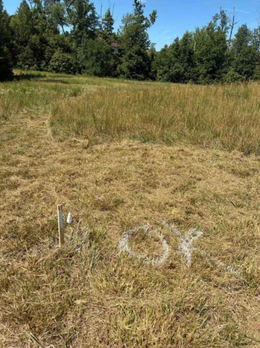
The American Society of Civil Engineers (ASCE) defines four Utility Quality Levels (QLs) in ASCE 38-22, Standard Guideline for Investigating and Documenting Existing Utilities, which establishes a consistent framework for communicating the reliability of utility information.
Quality Level D (QL-D) is the lowest level of confidence and relies solely on existing records, utility maps, or verbal recollections.
Quality Level C (QL-C) supplements those records by correlating them with visible surface features such as valves, hydrants, meters, or manholes.
Quality Level B (QL-B) involves surface geophysical methods - primarily electromagnetic locating and GPR - to determine the approximate horizontal position of underground utilities and is the level most commonly provided for design and preconstruction investigations.
Quality Level A (QL-A) provides the highest level of confidence by physically exposing the utility, typically through vacuum excavation or other nondestructive methods, to verify its exact horizontal and vertical location.
For geotechnical investigations, QL-B locating is often appropriate to support planning and reduce the risk of utility conflicts, while QL-A may be warranted where exploration points must be placed in close proximity to critical underground infrastructure or where the consequences of a utility strike are particularly severe.
This overall process and practice is commonly referred to as Subsurface Utility Engineering (SUE), which combines records research, surface geophysics, surveying, and selective utility exposure to improve confidence in existing utility information.
Many private utility locating contractors offer the option to collect geospatial data related to known, located, and clearly marked underground utilities using handheld GPS devices, and provide that information as a project deliverable. This information can be shared with the project team to provide value and risk mitigation beyond the geotechnical investigation.
However, even the most comprehensive utility locating program cannot guarantee that every underground utility will be identified, particularly where abandoned infrastructure, non-metallic utilities, or incomplete records exist.
The Cost of Getting It Wrong
Every underground utility strike carries consequences, but the severity can vary dramatically depending on what is damaged. An electrical strike may expose workers to serious injury or fatal electrocution. A damaged gas line can create an immediate fire or explosion hazard. Severing a fiber optic cable may interrupt communications for an entire facility or city. Damaging a private water or fire protection line can halt business operations and require costly emergency repairs.
Beyond the immediate safety concerns, utility strikes often result in:
Emergency repair costs
Project delays
Equipment downtime
Standby charges
Insurance claims
Increased premiums
Schedule impacts to multiple contractors
Potential legal disputes
Even when no one is injured, the indirect costs can far exceed the cost of performing private utility locating before field work begins.
Everyone Benefits from Proper Site Preparation
Vegetation clearing and private utility locating are sometimes viewed as unnecessary costs incurred solely for the benefit of the geotechnical consultant. In reality, they reduce risk for every stakeholder involved in the project.
Owners protect their existing infrastructure, reduce liability, and minimize disruption to ongoing operations.
Geotechnical consultants and drilling contractors are able to perform their work more safely and efficiently while reducing the likelihood of equipment damage or utility conflicts.
Design professionals receive more reliable subsurface information because exploration locations can be completed as planned rather than relocated in the field.
Construction contractors benefit from more complete site characterization and fewer project delays caused by unforeseen issues during the investigation.
Even the surrounding public benefits through reduced service interruptions and safer field operations. Good site preparation creates value for everyone.
Risk Management Is Better Than Risk Transfer
Construction contracts often contain language intended to allocate responsibility when something goes wrong. While these provisions serve an important legal purpose, they should never become a substitute for proper planning. No contractual clause can eliminate the consequences of an injury, a damaged utility, or a significant project delay.
The objective should never be determining who is responsible after an incident occurs. The objective should be preventing the incident from occurring in the first place. Investing in vegetation clearing and private utility locating is not simply about transferring liability - it is about actively reducing the likelihood of an event that no stakeholder wants to experience.
Preparing for Success
Before mobilizing a geotechnical investigation, owners and project teams should consider several straightforward steps:
Perform a site visit to document existing conditions and assess potential for private utilities and needs for vegetation clearing
Where necessary, clear vegetation around planned exploration locations and equipment access routes, removing brush, vines, fallen timber, and other surface obstructions where practical.
Clearly identify environmentally sensitive areas and limits of disturbance.
Contact 811 to request public utility marking.
Engage a qualified private utility locating contractor when private underground utilities may be present.
Provide available surveys, utility record drawings, and as-built information to the geotechnical team, along with proposed project designs.
Review utility markings and site conditions before field mobilization.
These relatively modest investments can prevent far more significant costs and delays later in the project.
A Small Investment That Protects the Entire Project and Project Team
Compared to the cost of a commercial development, transportation project, or industrial facility, vegetation clearing and private utility locating represent only a small fraction of the project design budget, and an even smaller fraction of the overall project cost.
Yet these activities can prevent injuries, avoid utility damage, reduce delays, improve investigation quality, and help keep projects moving forward safely. They offer one of the highest returns on investment available during the early stages of site development.
Ground Truth
At InnovoGeo Engineering, we view every geotechnical investigation as more than a data collection exercise. It is an opportunity to help our clients identify and manage risk before construction begins.
That process starts with thoughtful planning, clear communication, and a commitment to safety from everyone involved. The safest and most cost-effective geotechnical investigation doesn't begin when the first boring is drilled or the first CPT sounding is advanced. It begins with a properly prepared site, located and marked utilities, and a shared commitment to protecting the people, property, and projects entrusted to us. Because successful geotechnical investigations are built on preparation - not luck.